
Dosiero:(Vercelli) Italian Alps and plains (41587684585) (cropped).jpg

Fonta dosiero (905 × 910 rastrumeroj, dosiera grandeco: 150 KB, MIME-tipo: image/jpeg)
Resumo
| Priskribo |
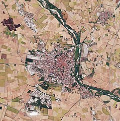
The Copernicus Sentinel-2B satellite takes us over the Italian Alps and down to the low plains that surround the city of Milan. The image captures the transition between the high snow-capped peaks of the Italian Alps and the flatlands of the northwest Po Valley. This transition cuts a sharp diagonal across the image, with the mountains in the top left triangle and the flat low-lying land in the bottom right. The southern part of the beautiful Lake Maggiore can also be seen in the image. Although its northern end crosses into Switzerland, Lake Maggiore is Italy’s longest lake and its character changes accordingly. The upper end is completely alpine in nature and the water is cool and clear, the middle region is milder lying between gentle hills and Mediterranean flora, and the lower end advances to the verge of the plain of Lombardy. The River Ticino, which rises in Switzerland and flows through Lake Maggiore, can be seen emerging from the lake’s southern tip. Here, the land, which is one of the most fertile regions in Italy, gives way to numerous agricultural fields, which are clearly visible to the west of the river. The city of Milan lies to the east of the river. In May 2019, Milan will host ESA’s Living Planet Symposium. Held every three years, these symposia draw thousands of scientists and data users from around the world to discuss their latest findings on the environment and climate. This image, which was captured on 9 October 2017, is also featured on the <a href="https://www.youtube.com/watch?v=4wVTwqMMOFc&lc=Ugyt_DqcyEzmpEDRNP14AaABAg" rel="noreferrer nofollow">Earth from Space video programme</a>. contains modified Copernicus Sentinel data (2017), processed by ESA, <a href="https://creativecommons.org/licenses/by-sa/3.0/igo/" rel="noreferrer nofollow">CC BY-SA 3.0 IGO</a> |
| Dato | |
| Fonto | Italian Alps and plains |
| Aŭtoro | European Space Agency |
| Ceteraj versioj |

_Italian_Alps_and_plains_(41587684585)_(cropped).jpg)
| Pozicio de la fotilo | | Tiu cxi bildo kaj pliaj sur OpenStreetMap |
|---|
_Italian_Alps_and_plains_(41587684585)_(cropped).jpg¶ms=045.851760_N_0008.849487_E_globe:Earth_type:camera_source:Flickr_&language=eo)
Permesiloj:
- Vi rajtas:
- kunhavigi – kopii, distribui kaj publikigi la verkon
- aliigi – modifi, adapti, kompletigi, transformi, uzi la tutan verkon aŭ ties partojn, memstare aŭ en aliaj verkoj
- La verko rajtas esti kunhavigata nur:
- atribuite – Vi devas atribui aŭtorecon, liveri ligilon al la permesilo kaj marki ĉu ŝanĝoj estis faritaj. Faru tion en aprobinda maniero, tamen ne sugestante, ke permesinto aprobas vin aŭ vian uzon.
- samkondiĉe – Se vi rekombinas la verkon, transformas ĝin aŭ kreas devenaĵon bazitan sur ĝi, vi rajtas distribui la rezultan verkon nur laŭ la sama aŭ kongrua permesilo kompare kun ĉi tiu.
| Annotations | This image is annotated: View the annotations at Commons |
Dosiera historio
Klaku daton/tempon por vidi la dosieron kia ĝi aspektis tiam.
| Dato/tempo | Bildeto | Dimensioj | Uzanto | Komento | |
|---|---|---|---|---|---|
| nuna | 22:29, 1 mar. 2020 | | 905 × 910 (150 KB) | Up and Go | File:Italian Alps and plains (41587684585).jpg cropped 93 % horizontally, 89 % vertically using CropTool with lossless mode. |
.jpg)
Dosiera uzado
La jena paĝo ligas al ĉi tiu dosiero:
Suma uzado de la dosiero
La jenaj aliaj vikioj utiligas ĉi tiun dosieron:
- Uzado en ca.wikipedia.org
- Uzado en gl.wikipedia.org
- Uzado en it.wikipedia.org
- Uzado en www.wikidata.org
_Italian_Alps_and_plains_(41587684585)_(cropped).jpg)